


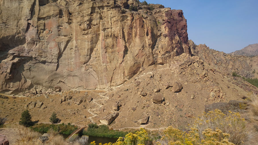
Brutal does not even describe the 1-mile, eastern side of the Smith Rock trail. Known as Misery Ridge, the 800-foot altitude accent on a narrow path offers spectacular cliffside views overlooking the Crooked River, making the climb well worth it. The Misery Ridge Trail itself, although short, connects to two other trails: Mesa Verde Trail, for only 0.4-mile, and a 1.7-mile River Trail, including the walk from Canyon Trail or The Chute path from the parking lot in total brings the Misery Ridge Loop to 4.0 miles, which takes you back where your journey began. If you are an out and back adventurist, you can hike up to the summit to see the infamous Monkey Face, then head back through the steep switchbacks. Located at Smith Rock State Park in Central Oregon about 42 kilometers or 26 miles from Bend; 15km or 9.3 miles from Redmond; 35km or 21.7 miles from Madras; 226km or 140.12 miles from Portland if you are traveling from the northwestern part of the state.
The distance from the day-use parking area varies depending on where you park. From the Welcome Center parking area there are numerous paths that lead to the start of the trailhead. One of those paths is a 0.5-mile path that has a mid-incline into the canyon below; the other is a 0.2-mile path with a steep incline which meets in the same location as the 0.5-mile path. Northwest of the path lies a bridge crossing the Crooked River where the Misery Ridge trail begins. The trail gets its nickname from the difficulty of the trail and is not associated with anyone historically, according to Smith Rock Park volunteer, Robert Murray. Murray mentions that Smith Rock State Park gets around 800,000 visitors a year and is busy during the springtime and the month of October when the temperatures are cooler.
-
A view of Misery Ridge trail from the summit.

-
On the top of Misery Ridge summit over looking Crooked River, Smith Rock State Park with Bureau of Land Management in the far distance.

-
A gorgeous view on the summit of Misery Ridge looking west.

-
Misery Ridge Trail sign at the top of the summit with hiking and rock climbing symbols.

-
From the back side of the Misery Ridge Loop trail you can see Monkey Face, at the summit.

-
On the westside of Misery Ridge Trail leading into River Trail, what is known as Misery Ridge Loop.

-
An emergency rescue kiosk located on the Misery Ridge loop trail.

-
A rock climber scales a wall at Smith Rock Park along the Mesa Verde Trail.


There are two ways that you can hike up to the summit. The backway follows The River Trail along Crooked River, forking off to the Mesa Verde Trail onto Misery Ridge main trail. The other way involves a steep descent with rocks, stairs, and zigzagging paths. Upon reaching the summit, you can see Smith Rock Park from all directions, at a 3,289-foot elevation overlooking the rest of Crooked River and Bureau of Land Management property to the East. Even though the trail has a steep accent, it is surprisingly popular with rock climbers and hikers. A group of out-of-town hikers and college friends, from Omaha, Nebraska, shared their experience, “I think it’s been fun. What I appreciate is (that) you’ve got these intense feats that are a steep incline, and then there’s a beautiful opportunity to pause at the top of that feet and admire the view and the landscape around you and whatnot,” said Erin Peters.
Peters described why they chose Misery Ridge “I’m traveling with two very good friends that I met in college and one of them, Jamie, is an incredible trip and experience planner. Like she literally does quality experience for a living. So, she planned this trip and Amanda, and I just had to show up…. We were talking about a four-hour loop completion effort or a 2.6, 1.3 in, 1.3 out. And we opted for that one as it was only going to take two hours, but She (Jamie) neglected to mention the name of that two-hour hike was Misery Ridge.”
One of the more interesting things that the hiking group saw was “We saw a lizard doing push-ups. We saw lizards doing push-ups, and that was awesome…yeah, he was like on all four legs, and he was just kind of up and down, up and down, up and down, and it was just adorable,” said Peters.
Jamie Watson, the trip planner and hiker, shared their thoughts on the hike along with the reasons why it was chosen, “I used AI to do it and I was like, what are some really good ideas? What would be regrettable to miss here? And then kind of fleshed it out and then looked up the things. And it said this was a good trail, and it actually said it was a moderate trail. And just getting out here, we’re like, this is actually a hard trail. But it’s beautiful and I’m glad that we did it.”